Lake Pend Oreille

So much to do on Idaho's largest lake

Magnificent Lake Pend Oreille, the ‘home port’ for Sandpoint, Idaho,  offers a host of activities come spring and summer

A gorgeous lake, and so much to do!

Want to go deep in summer? You can do that in Lake Pend Oreille, Idaho’s largest lake and the fifth deepest in the entire nation with depths exceeding 1,100 feet. Lake Pend Oreille offers a summer playground of pristine waters, scenic shorelines, and endless recreational opportunities. 

Swimming
Sandpoint City Beach, located right downtown, is a favorite for families and sunseekers, with sandy shores, panoramic views, and tennis, volleyball and basketball courts, horseshoe pits, plus playgrounds for kids. Other top swimming spots include the inviting beaches at Sam Owen Campground on the Hope Peninsula, or farther south, Farragut State Park, one of Idaho’s premier parks.

Paddling
Lake Pend Oreille’s protected bays are perfect for kayaks, canoes and paddleboards. From Sam Owen Campground near Hope, paddlers can explore quiet coves and islands such as Warren, Cottage, and Pearl. The Pack River and Clark Fork deltas, where river waters meet the lake, are calm, wildlife-rich zones of backwaters and channels ideal for nature lovers.

Boating & Cruises
A number of power boat rentals are available in Sandpoint and Hope for craft ranging from pontoon boats to jet skis. Even more accessible are the daily outings offered by Lake Pend Oreille Cruises on the classic Shawnodese tour boat. If your tastes run to sailing, connect with Dogsmile Adventures, with boats in Sandpoint and Bayview.

Walks & Hikes
Trails around the lake offer stunning views and peaceful escapes. Among lakeside trails, the Pend d’Oreille Bay Trail provides an easy, scenic walk just steps from downtown Sandpoint. For something wilder, head to the Lost Lake-Mineral Point trails near Garfield Bay. Other hikes up in the mountains afford amazing lake views, among them the trails at Schweitzer, Mickinnick and Scotchman Peak.

Lake Pend Oreille Activities

The Idaho Club

Barely 10 minutes from downtown Sandpoint, The Idaho Club is Idaho’s only Jack Nicklaus Signature Golf Course. In 2008, Nicklaus Designs and Jack Nicklaus himself designed this golf course that provides a world-class golf experience while immersing players in the natural beauty of the lower Pack River estuary.

This exceptional 18-hole championship course offers a challenging course that’s renowned for its water hazards, served up amid scenery that is just as captivating as the fairway. The Idaho Club’s new 7,500-square-foot, mountain-modern style clubhouse offers a fine restaurant and pro shop and blends seamlessly with the scenic surroundings. With mountains as your backdrop and the river meandering throughout the course, you’ll have an unparalleled experience at The Idaho Club. Click to the club’s website to explore more.

Mickinnick Trail

One of the closest and nicest hikes adjacent to Sandpoint, the Mickinnick is a challenging trail that rises more than 2,000 feet in its 3.5-mile length to the topmost overlook – meaning, a round-trip hike is a fairly strenuous 7 miles. But even if you don’t make it to the top, there are expansive viewpoints at several spots along the way.

The trail wends trough big granite features amid open forests and, in spring and early summer, profuse displays of many different kinds of wildflowers. On warm summer days, the east-facing aspect of the trail makes it more user-friendly in the afternoon. The trail ends on a rocky knob commanding a view of Sandpoint, the Long Bridge, the Cabinet Mountains and Lake Pend Oreille. Use the Google map to navigate to the trailhead parking, at roughly 400 Woodland Drive, or click to the Forest Service map and elevation profile.

Trail particulars: To get to the trailhead from Sandpoint, take Highway 95 north 1.3 miles to Schweitzer Cutoff Road; turn left and go a half mile; turn right and go less than a mile to turn left on Schweitzer Mountain Road (at Schweitzer Sign); go one-half mile to Woodland Drive; turn left and go 0.7 miles. The trailhead parking, with pit toilet, water and map, is on the right.

Kootenai National Wildlife Refuge

Offering terrific wildlife experiences (especially in the “high” seasons of fall and spring) the 2,774-acre Kootenai National Wildlife Refuge’s wetlands, meadows, riparian and coniferous forests, and cultivated agricultural areas are interspersed throughout the refuge to provide a sanctuary, primarily for migrating waterfowl.

During spring, and especially fall, when birds are moving along the Pacific Flyway, there may be thousands of ducks, geese and swans resting and foraging at the refuge ponds. But there’s more than waterfowl. Over 300 species of wildlife have been observed on the refuge: 22 species of fish, 7 species of amphibians, 6 species of reptiles, 45 species of mammals, and over bird 223 species.

The refuge has easy and flat hiking trails, wildlife blinds and a driving route offering multiple ways to see and experience the wildlife and its beautiful location in the Kootenai River valley, framed by the Selkirk Mountains to the west and the Purcell Range to the east.

For the latest information on the refuge, with details for visiting, check the website: Kootenai National Wildlife Refuge.

Scotchman Peak Trail

This trail up Scotchman Peak – the highest point in Bonner County at 6,872 feet – is a bit over 4 miles to the top, and strenuous: There’s more than 3,700 feet of vertical gain. But the payoff is big views over Lake Pend Oreille to the south and various peaks in the Cabinet Mountains in all other directions. Plus, there’s a resident herd of mountain goats that frequent the peak, affording a good chance of seeing the amazingly sure-footed mountain climbers up close. Hikers are asked to keep a distance of 100 feet, for their safety as well as the goats. In summer you’ll likely see other hikers on this trail, as it’s a popular one, but in other seasons the trail traffic declines.

This hike has a ceaseless advocate in Friends of the Scotchman Peaks Wilderness.

More information at Friends of Scotchman Peaks Wilderness.

Trail map and information at the Hiking Project.

Round Lake State Park

This intimate park is a family favorite. Located a dozen miles south of Sandpoint, Round Lake offers seven miles of trails that are relatively flat and easy, suitable for walks and biking, as well as a host of other outdoor activities.

Visitors often spot wildlife, as Canada geese pass over the park’s towering pine, hemlock and larch trees and ospreys plunge for perch. Hikers will discover beaver lodges and may see a glimpse of a resident moose, while along the lake in summer you may hear a chorus of bullfrogs and spot ducks and Red-winged Blackbirds among other birdlife.

The 58-acre lake is stocked with rainbow trout and has a good bass fishery. There’s fine fishing for kids, right from the dock or by paddle craft on the lake; no gas motors are allowed. The lake also makes for a refreshing swim in the warm months.

There are 16 serviced campsites and 35 standard sites. There are guided walks and ranger programs in summer; in winter, depending on conditions, there are opportunities for ice skating, sledding, fishing or a picnic, often served up with a roaring bonfire. As well in winter, trails are marked and groomed for cross-country skiing.

For a map or more information, call 208-263-3489; or click parksandrecreation.idaho.gov/parks/round-lake/.

Pine Street Woods

The Pine Street Woods little more than two miles from downtown Sandpoint is a unique place where people of all ages and abilities have the opportunity to be outside. The wide trails welcome strollers, wheelchairs, or friends walking side by side, and nordic skiers in the winter. More than a dozen trails make for miles of hiking and biking or cross-country skiing and fat-biking in the winter.

Trails are for non-motorized use. Electric bikes are welcome. Horses are not encouraged at Pine Street Woods because of the numerous off leash dogs and mountain bikes that frequent the property. (Also, the access road and parking lot do not accommodate horse trailers.)

There are no usage or parking fees. Pine Street Woods is open to all and is supported through generous trail donations and gifts from users just like you.

Pine Street Woods sits adjacent to two other public access properties. Collectively, the three properties comprise the Syringa Trail System. As is the case for Pine Street Woods, the Sherwood Forest and VTT properties are also privately owned, but are not owned or managed by KLT. The owners graciously allow the public to enjoy these special places, only requesting that everyone respect the land, wildlife, and other visitors.

Signage provides maps at the main trailhead, but click to see maps here:

Pine Street Woods on Trailforks »

Printable Trail Map »

Gold Hill Trail

The Gold Hill Trail is one of the most popular for local hikers and mountain bikers, a 3.7-mile track that can be moderate or strenuous – depending on whether you hike or ride it up or down, or as most do, both ways.

If you are ready to enjoy all the adventure and scenic outdoor recreation that the Sandpoint, Idaho area offers, this is one trail that you don’t want to miss for a terrific hike or bike ride.

The trail leads uphill through a forested setting to panoramic northwest-facing views of Sandpoint across Lake Pend Oreille with the Selkirk Mountains behind.

Most start at the trailhead on Bottle Bay Road, about 8 miles south of Sandpoint; navigate to the trailhead parking by the Google map. It is possible to circle around by forest roads and access the trail up near the viewpoints.

Many mountain bikers do this as an out-and-back, starting at the trailhead for the uphill singletrack. However, some ride an extended route at the top of Trail 3, to include Gold Mountain and forest roads. Or, to make a full day that includes miles on paved and gravel backroads you can include the trail as part of an approximately 28-mile loop right from Sandpoint itself riding to the trailhead via the Long Bridge bike and pedestrian route.

This is mountain hiking and biking at its best in the Pacific Northwest!

Click for USFS trail map and details: Forest Service Gold Hill Trail No. 3.
Click for extended route details: MTB Project Gold Hill Trail No. 3.

Evans Landing Trail

Evans Landing Trail leads 2 miles down to a beach at the landing on the west side of Lake Pend Oreille. A multitude of switchbacks make for a gentle grade, beginning at the top of Kreiger Creek on Trail No. 64. The slope becomes extremely steep closer to the lake, however. The remains of an old cabin are tucked away behind some ponderosa pine trees, and nearby is a picnic table on the edge of the stony beach, plus a vault toilet. Access is 17 miles south of Sandpoint on U.S. Highway 95 via the southern end of Blacktail Road. Follow it east 2.6 miles to Little Blacktail Road, turn east again and go another 2.6 miles past one trail sign to East Ridge Road where a second trail sign indicates the way to the trailhead. Take a right on East Ridge Road, go a half mile and turn left onto a short spur road and the parking area.

Maiden Rock Trail

Maiden Creek Trail is a steep 2-mile trail that leads down Maiden Rock, a prominent geologic feature, and a Forest Service recreation site on Lake Pend Oreille. The trail to this magical spot on the lake’s western shore is fairly short, though quite steep as you get closer to the lake. It cuts through a dense forest in a deep notch between two mountains to where the waters of Maiden Creek first gurgle to the surface. It follows the creek steeply downhill to the lake. Access is 11 miles south of Sandpoint on U.S. Highway 95 via the north end of Blacktail Road. Go 1.5 miles to Butler Creek Road No. 230. Turn left and travel three miles to the trailhead.

Schweitzer biking and hiking

Looking for a fun and adventurous way to take in the fresh mountain air and beautiful views? Whether you’re a hiker or biker, Schweitzer offers more than 20 miles of trails with amazing alpine scenery and see-forever views.

Start in the village and warm your legs up as you head out to Picnic Point – with only minor climbing – to take in the sweeping views of the mountains and Lake Pend Oreille. From there, your options are wide open. For those looking for a pure downhill biking thrills, Schweitzer has many intermediate to expert options with a chairlift assist to the top; all downhill trails begin at the top of the Great Escape Quad and descend 1700 feet to the Schweitzer Village.

Pick up detailed trail maps in the village, or click for the map below. Mountain bike and e-bike rentals are available in the village.

Click for Schweitzer trails map»
Click for Schweitzer on Trailforks»
Click for all Schweitzer activities»

Lost Lake - Mineral Point Trail

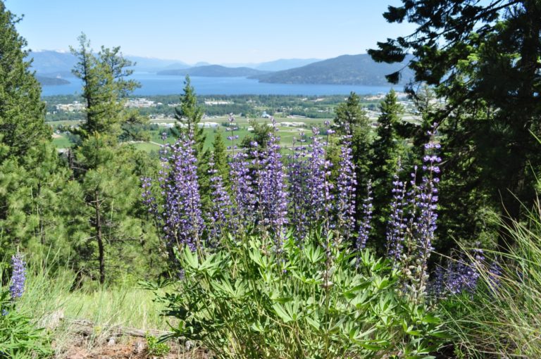
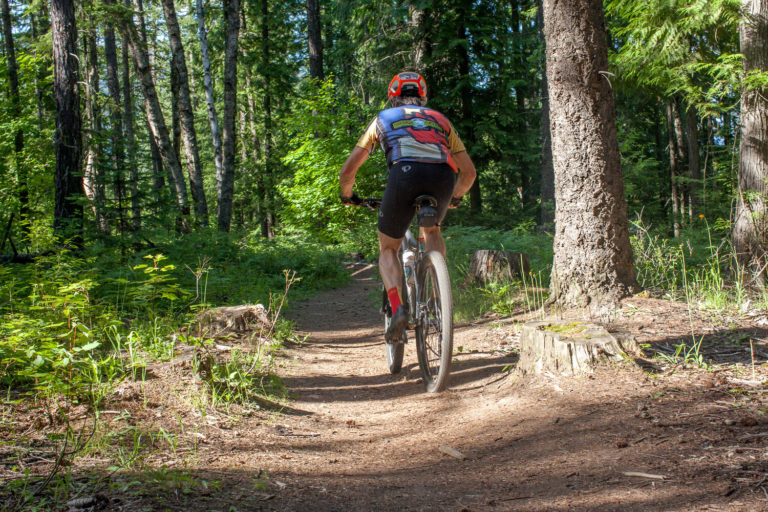
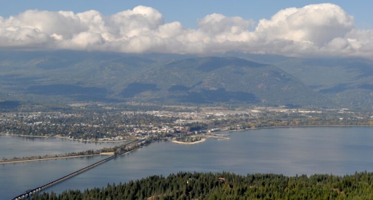
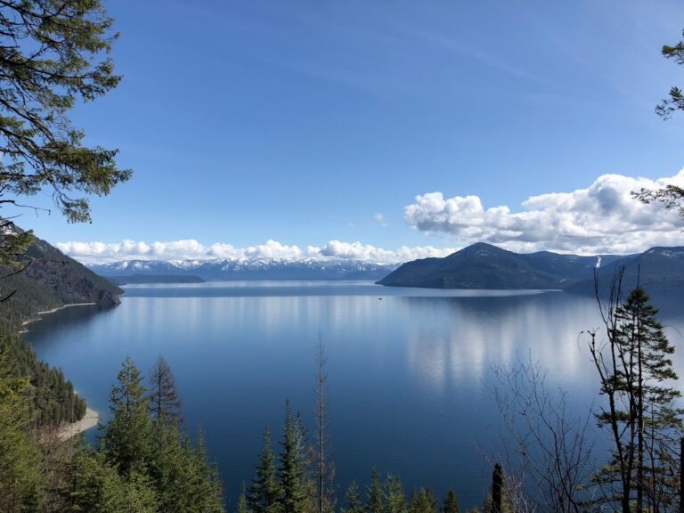
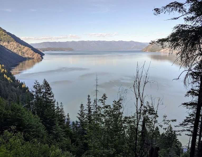
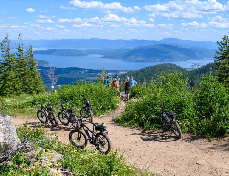
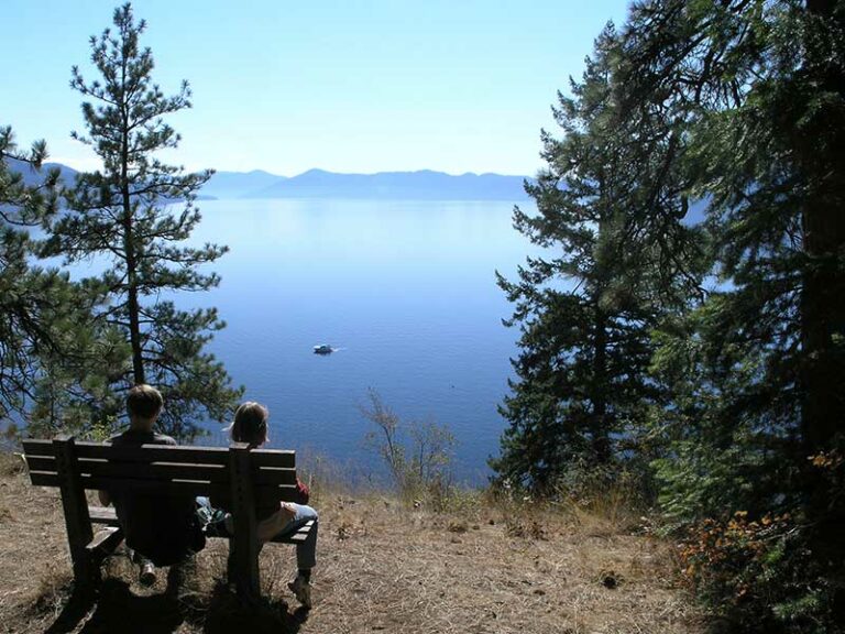
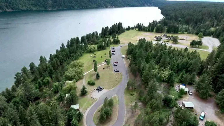
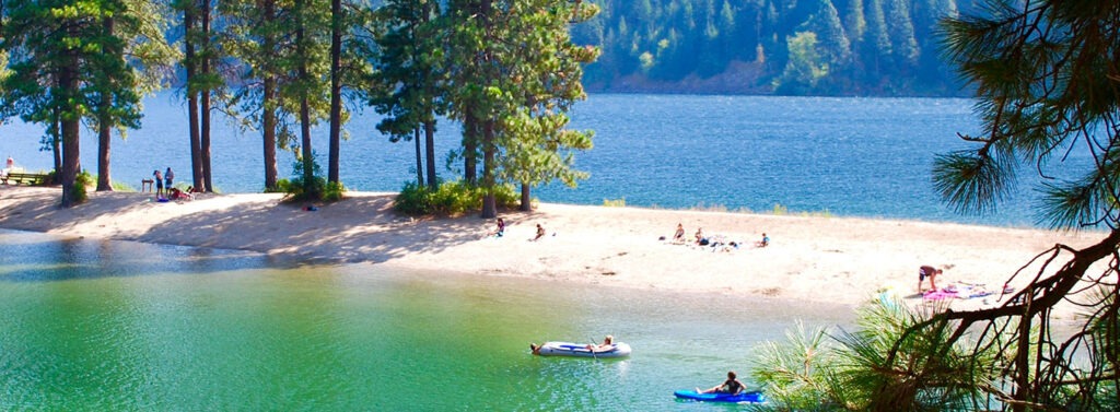
Here’s a ride or walk about 14 miles from Sandpoint that provides big views of the southern arm of Lake Pend Oreille, with swimming at the fine cobblestone beach at Green Bay, where there is a campground and day use area. One segment of the single track trails for mountain bikers and hikers is an easier loop around Lost Lake, while the Mineral Point trail itself provides a more challenging – but doable – ride for beginners, with outstanding views of Lake Pend Oreille and the Green Monarchs. The trail is popular with both hikers and bikers, so bikers are advised to ride carefully.

Mineral Point Trail has two main trailheads. You may start at Green Bay, from whence you’ll immediately climb up the bluffs above the lake with magnificent views across the lake to the Green Monarchs. There’s a 2.1 mile hike or ride to the second access point, which also provides the trailhead to the roughly six miles of Lost Lake trails.

Click for a printable map»
Click for Trailforks mapping»

To the trailhead: From Sandpoint, drive six miles south on Highway 95 to Sagle, and turn east onto Sagle Road. Continue a bit more than six miles to the junction where Garfield Bay Road forks to the right and continue another roughly two miles to the waterfront village of Garfield Bay. There’s a small park in Garfield Bay; to make this ride longer, we suggest parking there in Garfield Bay and starting your ride on the backroads there. From Garfield Bay Road, find Green Bay Cutoff Road, which proceeds north. The cutoff will quickly become a gravel road; go about .4 mile and turn right onto the Mineral Point Road No. 532 (next to the red firehouse) and ride 2.2 miles on Road 532, and turn right for 0.3 miles the Mineral Point trailhead. The trail will then take you on 2.1 miles of singletrack high along the lakeshore, dropping down to the Green Bay campground and beach, a great place to stop for a swim or to hang along the lake. To complete the loop, ride back up the steep access road from the campground back to Mineral Point Road, then back to Garfield Bay.

Trail particulars: There is only about 400 feet of elevation gain and loss but you’ll hike or ride it up and down several times. Water and toilets are available at Green Bay. At the trailhead for Mineral Point Trail there is a vault toilet.

Farragut State Park

With more than 9 miles of mostly flat ‘n’ easy trails for hiking, mountain biking and XC skiing in winter – and many outstanding views of the lake – Farragut is a terrific family recreation destination. 

Located on the southern tip of Lake Pend Oreille, about 40 minutes driving time from Sandpoint via U.S. Highway 95, Farragut is a crown jewel of Idaho’s state parks. Camping and lake activities, with boat launch and fine swimming areas plus good fishing spots from shore, are prime here. There are also five different disc golf courses.

Get park details on the Farragut State Park web page»
Get trail maps on Trailforks for Farragut»
Get details and course maps on Farragut disc golf»

Priest Lake State Park

Priest Lake State Park lies just 30 miles from the Canadian border, nestled deep below the crest of the Selkirk Mountains. Surrounded by the natural beauty of Northern Idaho and mile-high mountains, Priest Lake State Park sits along the eastern shores of Priest Lake, a 19-mile long, 300-foot-deep waterbody.

Visitors to the park will enjoy the dense forests of cedar, fir and tamarack and will be able to observe the park’s year round inhabitants such as the whitetail deer, black bear, moose and bald eagles. Noted for its extremely clear water, fed by streams cascading from the high Selkirk peaks, the main body of Priest Lake extends north-south for 19 miles. A two-mile thoroughfare connects the main lake to the remote Upper Priest Lake that is accessible only by foot, mountain bike, or boat.

Sandpoint Elks Golf Course

Sandpoint Elks Golf Course is little more than a mile northeast of downtown Sandpoint off Highway 200, with a well-maintained 9-hole course, equipment and cart rental, friendly clubhouse and affordable rates, as well as a restaurant and bar that is a gathering place for golfers as well as many community functions. Double tee boxes provide an 18-hole experiences as well!

Call for a tee time, or click to the website for more details.

Mirror Lake Golf Course

Mirror Lake Golf Course is a gem of a 9-hole course, located just 30 minutes north in Bonners Ferry. It is player friendly for the beginner, yet is a challenge for the low handicap golfer as well, with two sets of tees for the front and back nines. It has a diverse array of par 3s, 4s, and 5s, along with stunning views of the Selkirk Mountains and the Kootenai Valley stretching north. The golf course features water hazards on both par 3s as well as on three of the par 4s. The course is in wonderful shape with fast and smooth putting greens.

The golf course also provides a practice green, driving range, full-service Pro Shop, snack bar, and cocktail lounge.

From the back tees, the course measures 6001 yards with a slope of 117 and a course rating of 68.4 for the men, while the forward tees are 5256 yards with a slope of 123 and a course rating of 70.8 for the women. Par is 72 for both sets of tees.

Visit the website to see more and secure a tee time.

Schweitzer Village

Our nationally recognized mountain resort is only 11 miles from downtown Sandpoint, with 2900 acres for skiing, hiking, biking and magnificent alpine views and a resort village featuring premium lodging, dining, bars, fine outdoor clothing and gear, shopping, artists studio, and seasonal activities.

7B Lanes

Family Fun Center, Bowling, Arcade, Good Food and Drink, and Pool Tables!

The Library

Discovery, connection, and lifelong learning through books and other resources; accepts library cards from around the world.

Stay Connected

Signup for the Visit Sandpoint newsletter!

Our newsletter goes out at the first of each month with a roundup of events and activities you’ll want to know about! Easily unsubscribe at any time.